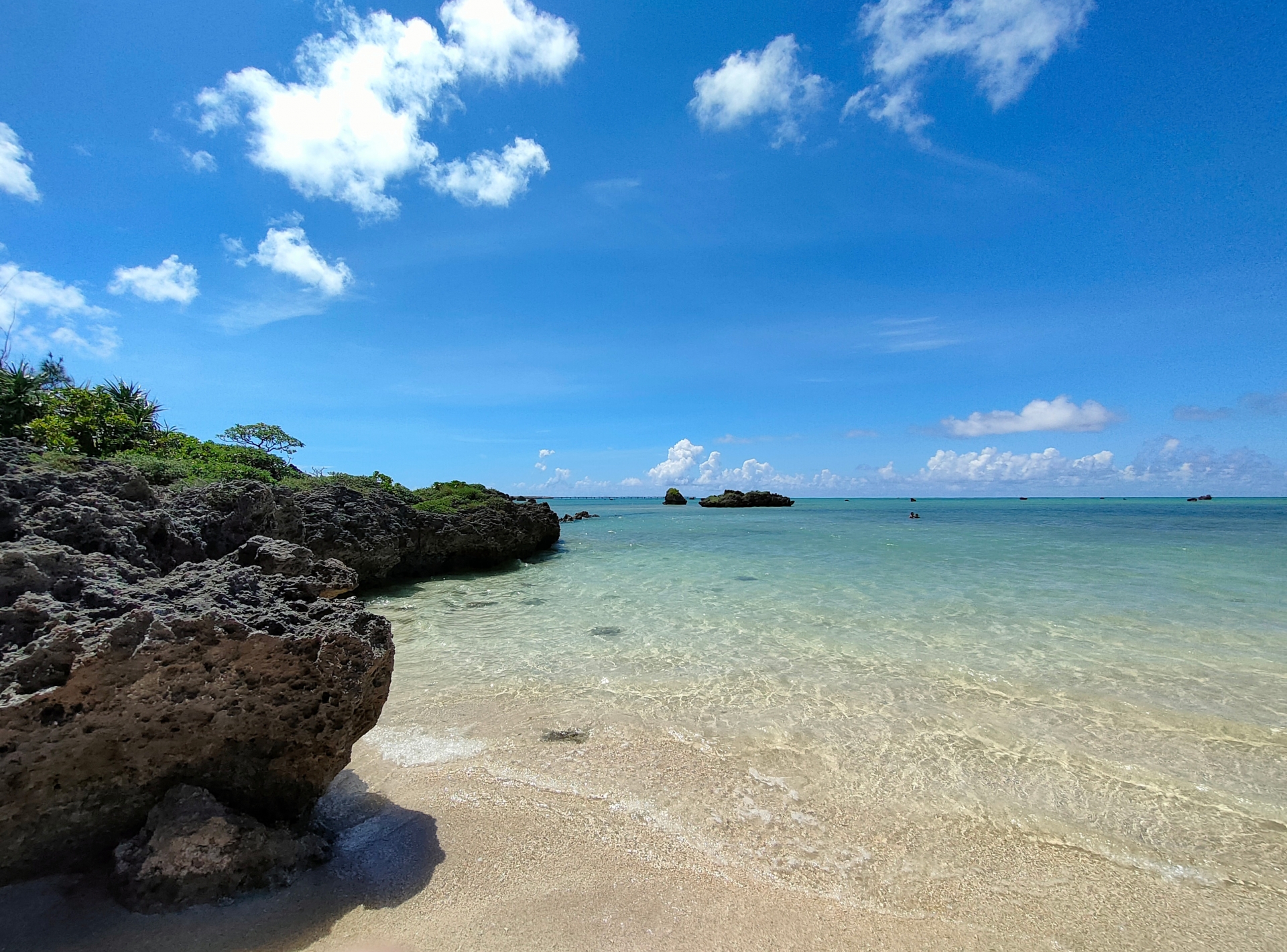
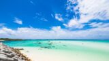
When I first crossed the Irabu Bridge into Irabu Island, the very first thing I felt was "it's flat." There are no mountains like on Okinawa's main island or Ishigaki Island, and low, flat terrain spreads as far as you can see. And the blueness of the sea spreading before you. The transparency is abnormally high, and "why is it this beautiful?" slipped out of me.
In fact, this flat terrain and clear sea have a deep reason. Both Irabu Island and Shimojishima are islands made of "uplifted coral reef." In the distant past, a coral reef that was in the sea was pushed up by crustal movement to form the island. So it's flat, and so the sea is beautiful.
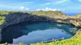
This time, I'll explain the natural environment of Irabu Island and Shimojishima from a scientific viewpoint — terrain, geology, the mechanism of water and so on. "Geology" sounds difficult, but knowing it changes how the scenery looks. The view gazed at from Makiyama Observatory, the blue water of Toriike Pond, the white sand of Sawada-no-Hama — all of it clicks into "I see!"
By knowing the nature of Irabu Island and Shimojishima, you should be able to understand this island's appeal more deeply.
- A Flat Island Created by an Uplifted Coral Reef | The Basic Terrain of Irabu Island and Shimojishima
- Oval-Shaped and Higher on the East | Irabu Island's Terrain Features
- Ryukyu Limestone and the Freshwater Lens | The World of Water Spreading Underground
- Makiyama and the Fault Scarp | The Geological Secret Hidden at the Island's Highest Point
- The Superb Views Created by Irabu Island and Shimojishima's Natural Environment
A Flat Island Created by an Uplifted Coral Reef | The Basic Terrain of Irabu Island and Shimojishima
Irabu Island is an island located about 4 km northwest of Miyako Island.
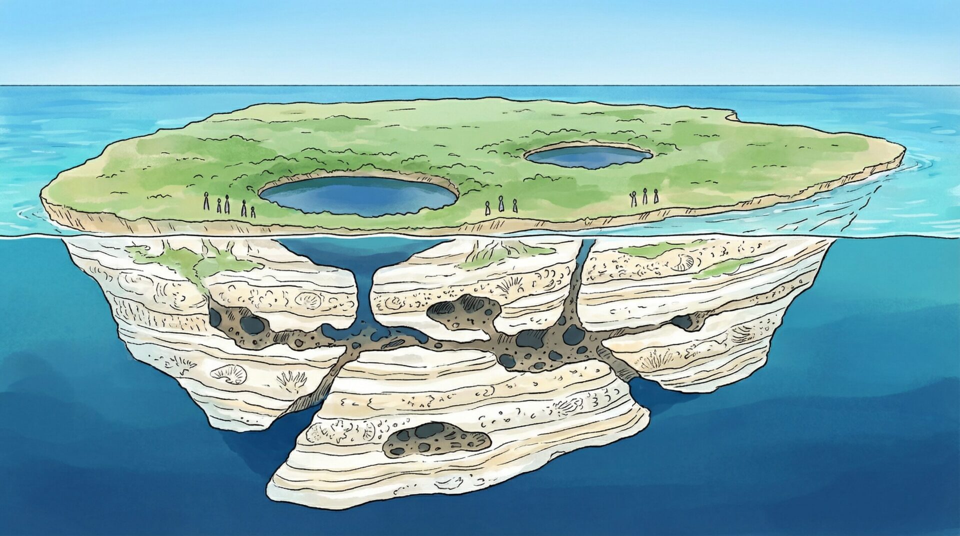
It's known as an island with thriving bonito fishing, but seen geologically it's a very distinctive island, with the whole island made of uplifted coral reef (Ryukyu limestone).
"What's an uplifted coral reef?" you'd wonder. Simply put, it's land formed when a coral reef that was once in the sea was pushed up above sea level by crustal movement. In other words, the ground of Irabu Island we walk on now was, tens of thousands of years ago, a coral reef on the seabed.
When I first learned this fact, I was surprised — "what, this whole island is made of coral?!" Driving the roads, there are occasional spots where the rock face shows, and looking closely it's certainly whitish and porous. "Ah, this is coral limestone," you realise.
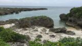
On the west side of Irabu Island, Shimojishima is adjacent. The two islands are separated by an inlet (channel) 40–100 metres wide, and are now connected by six bridges. Looking down at this channel from atop a bridge, an emerald-green sea flows, incredibly beautiful.
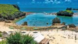
Shimojishima, like Irabu Island, is an island formed by an uplifted coral reef. Its area is a compact 9.8 km² or so, but the terrain is flat, and the highly transparent sea and white-sand beaches draw tourists. 17END, Toriike Pond, Nakanoshima Beach — every one of Shimojishima's sightseeing spots is characterised by overwhelmingly transparent sea, isn't it.
Both Irabu Island and Shimojishima have flat terrain across the whole island. Miyako Island is the same — there are no high mountains. So the sky feels incredibly wide. And the horizon continuing endlessly. This sense of openness is one of the appeals of Irabu Island and Shimojishima.
Oval-Shaped and Higher on the East | Irabu Island's Terrain Features
Looking at Irabu Island on a map, it's a long oval running northeast to southwest.
According to Cabinet Office materials, Irabu Island is an oval island with its long axis running northeast to southwest, higher on the east side and gently sloping toward the southwest.
Even saying "higher on the east side," there's no high mountain. Irabu Island's highest point is Makiyama, at an elevation of just 89 metres. But these 89 metres are the island's highest point. It's that flat an island.
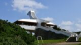
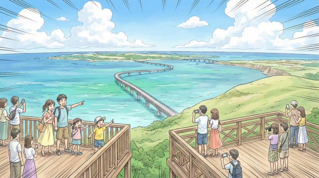
When I first went to Makiyama Observatory, I thought "huh, this is the highest place on the island?" But the view from the observatory was spectacular. The Irabu Bridge is right in front, and Miyako Island, Shimojishima and the sea can all be taken in. That you can see this much view despite only 89 metres is because the whole island is flat. With no tall buildings or mountains, there's nothing to block the view.
On the east side of Makiyama there's a fault scarp running northwest to southeast. I'll describe this later, but it's a geologically interesting terrain too.
And on the west side of the island, Shimojishima is adjacent across the shallow, narrow Kuninaka inlet (channel). This Kuninaka inlet is really narrow. Seen from atop a bridge, it makes you think "huh, it's this close?" But an emerald-green sea flows in that narrow channel, incredibly beautiful.
Irabu Island's oval terrain and gentle slope are clear when driving. Cross the Irabu Bridge into the island and head toward Makiyama, and you feel the altitude gradually rising. But there's no steep slope — really gentle. And heading southwest, it gently descends again. This subtle undulation gives the island's scenery variety.
Ryukyu Limestone and the Freshwater Lens | The World of Water Spreading Underground
Irabu Island's geology is composed of the Quaternary Pleistocene Ryukyu Group (coral limestone).
To explain a bit more, the base is a layer of sandstone and mudstone called the Shimajiri Group of the Neogene to Quaternary Pleistocene, with Ryukyu limestone resting on top of it. It gets technical, but in short "on top of older-era rock, limestone made of coral is layered."
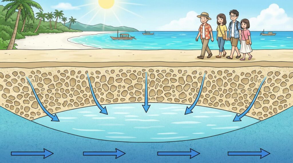
This Ryukyu limestone actually has incredibly high water permeability. "Water permeability" is the property of letting water through easily. Coral limestone is porous, with lots of small holes open, so water soaks in like a sponge.
When it rains, the rainwater doesn't stay on the surface but immediately permeates into the limestone. And it pools underground. This layer of fresh water pooled underground is called a "freshwater lens."
A freshwater lens is a groundwater basin. On an island surrounded by the sea, when fresh water pools underground, that fresh water, being lighter than seawater, exists as if floating on top of the seawater. Seen in cross-section it's shaped like a lens, which is why it's named "freshwater lens."
This freshwater lens is formed across the whole of Irabu Island. In the old days, this groundwater was used as a precious source of drinking water. Old well remains like Sabautsugaa (Saba offshore well) survive on the island. When I first went to Sabautsugaa, I descended 123 stone steps to reach a well near the shore, and was surprised — "fresh water sprang this close to the sea." That's the mechanism of the freshwater lens.
And here's the important point.
Rainwater permeating into the limestone and pooling underground means there are almost no rivers or lakes on the surface. In fact, neither Irabu Island nor Shimojishima has a river. Even when it rains, the water soaks straight into the ground. So earth and sand hardly ever flow into the sea.
This is one of the reasons the transparency of the Miyako islands' sea is abnormally high.
Okinawa's main island and Ishigaki Island have rivers. When it rains, the river water carries earth and sand into the sea. So after heavy rain the sea turns cloudy. But Irabu Island and Shimojishima have no rivers. No earth and sand flow into the sea. So even when it rains, the sea's transparency is maintained.
When I first learned this mechanism, I was convinced — "so that's why Irabu Island's sea is this beautiful!" The white sands and transparent sea of 17END, the emerald green of Toguchi-no-Hama, the transparency at Nakanoshima Beach where you can see tropical fish. All of it is thanks to this geology and the mechanism of water.
Makiyama and the Fault Scarp | The Geological Secret Hidden at the Island's Highest Point
Irabu Island's highest point is Makiyama, in the southeast of the island. Elevation 89 metres.
"89 metres is only about as high as a 30-storey building," you might think. But on Irabu Island this is the highest point. And around this Makiyama there's geologically very interesting terrain.
Around Makiyama there's a fault scarp with a relative height of about 60 metres.
A "fault scarp" is a cliff formed by a fault (a place where strata have shifted). On the east side of Makiyama there's a fault scarp running northwest to southeast, and this fault divides the marine terrace surface into two.
A "marine terrace" is flat terrain formed when an old coastline was pushed up by crustal movement. Since Irabu Island is an uplifted-coral-reef island, sea levels rose and fell many times and the crust uplifted, forming multiple terraces.
Gazing at the view from Makiyama Observatory, you can tell "certainly, the height differs between this side and that side." The east is high, the west is low. At the boundary there's a fault, with a 60-metre height difference. This height difference gives the island's terrain variety.
When I first climbed Makiyama Observatory, I just thought "the view is beautiful." But when I visited again after learning about the fault scarp, how it looked was completely different. Thinking "that step is the fault scarp," "this scenery was created by crustal movement over tens of thousands of years," a mere observatory comes to look like a geopark.
Makiyama is the only place on Irabu Island you can call "high." The figure of 89 metres elevation sounds like nothing, but within a flat island it's an overwhelming height. And around it there's the geologically important terrain of a fault scarp. This is what makes Makiyama special.
If you visit Makiyama Observatory, please by all means recall this geology story too. The view before you should change from a mere "beautiful view" to "a work of art of the Earth made over tens of thousands of years."
The Superb Views Created by Irabu Island and Shimojishima's Natural Environment
So far, I've explained Irabu Island and Shimojishima's terrain, geology and the mechanism of water.
To sum up, it's like this:
- Uplifted-coral-reef islands: the whole island is composed of limestone made of coral
- Flat terrain: no high mountains, with low, flat terrain spreading as far as you can see
- Oval and higher on the east: Irabu Island runs long northeast to southwest, with the east (Makiyama) the highest point
- Ryukyu limestone and the freshwater lens: highly permeable limestone pools rainwater underground, and there are no rivers
- Beautiful sea because there are no rivers: with no earth and sand flowing in, the transparency is abnormally high
- Makiyama and the fault scarp: the 89-metre highest point and a 60-metre fault scarp
These geological features create the superb views of Irabu Island and Shimojishima.
The white sands and transparent sea of 17END are a transparency realised because there are no rivers. The emerald green of Toguchi-no-Hama is because the white sand of coral limestone spreads across the seabed. The mysterious blue of Toriike Pond is because seawater has entered a collapse doline in the limestone. The strange rock formations of Sawada-no-Hama are a combination of rocks carried by the Great Meiwa Tsunami and the uplifted-coral-reef terrain. The 360-degree panorama view from Makiyama Observatory is scenery realised because the whole island is flat.
By knowing the natural environment, you can deeply understand the meaning of the sightseeing spots.
When I first visited Irabu Island, I only thought "beautiful sea," "flat island." But visiting after learning the mechanism of the geology and terrain, every view clicks into "I see!" Scientific knowledge makes the journey more interesting.
If you visit Irabu Island and Shimojishima, please by all means keep these features of the natural environment in a corner of your mind. Walking the beach and thinking "this white sand is made of coral," a mere beach comes to look like a special place. Entering the sea and thinking "it's this transparent because there are no rivers," you understand the preciousness of this transparency.
The natural environment of Irabu Island and Shimojishima is a miracle of the Earth made over tens of thousands of years. On top of that miracle, we enjoy our travels. Thinking that, this island should become even more dear to you.